My Genealogy Hound
Washington County, Arkansas 1909 Map
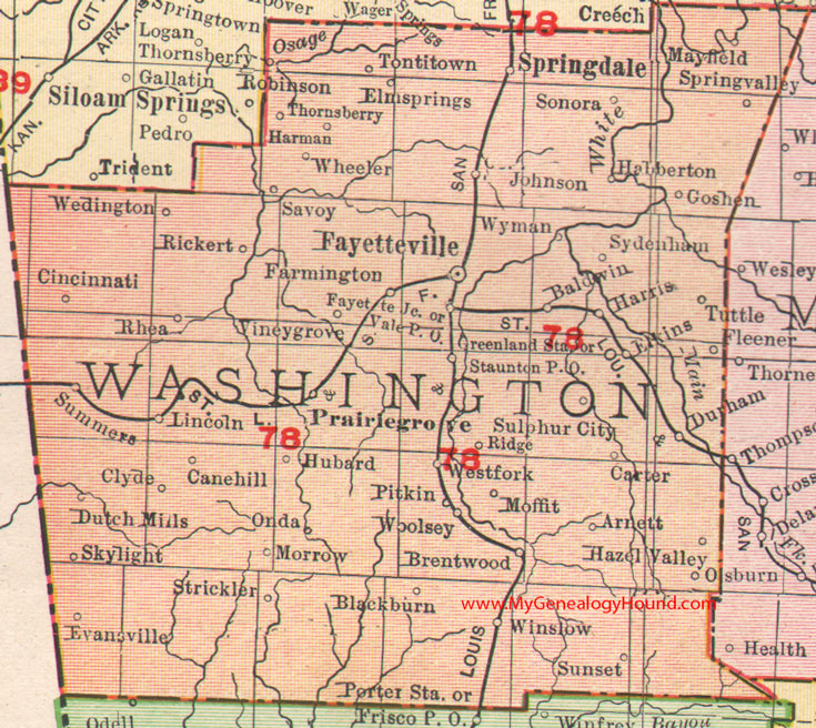
Locations shown include: Arnett, Baldwin, Blackburn, Brentwood, Cane Hill, Carter, Cincinnati, Clyde, Durham, Dutch Mills, Elkins, Elm Springs, Evansville, Farmington, Fayette Junction, Fayetteville, Fleener, Goshen, Greenland Station, Habberton, Harman, Harris, Hazel Valley, Hubbard, Johnson, Lincoln, Mayfield, Moffit, Morrow, Onda, Osburn, Pitkin, Prairie Grove, Rhea, Rickert, Ridge, Savoy, Skylight, Sonora, Springdale, Spring Valley, Staunton, Strickler, Sulphur City, Summers, Sunset, Sydenham, Thornsberry, Tontitown, Tuttle, Vale, Viney Grove, Wedington, West Fork, Wheeler, Winslow, Woolsey, Wyman
The large red numbers identify railroad lines:
78: St. Louis & San Francisco Railroad
This is a portion of a Arkansas map published by Rand McNally & Co., 1902, 1909.
View family biographies from the 1889 History of Washington County: Washington County, Arkansas
View additional Arkansas Maps here: Arkansas County Maps
County maps from other states can be viewed here: State County Maps
Additional Washington County resources: Washington County, Arkansas History, Genealogy, and Maps
Use the links at the top right of this page to search or browse thousands of family biographies.