My Genealogy Hound
Benton County, Arkansas 1909 Map
View additional Benton County Maps here: Benton County, Arkansas Maps
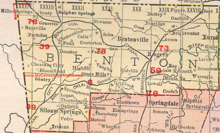
Locations shown include: Avoca, Beaty, Bentonville, Bloomfield, Brightwater, Buttry, Calis, Cannon, Cave Springs, Centerton, Cherokee City, Clementine, Colville, Creech, Decatur, Gallatin, Garfield, Gentry, Glade, Gravette, Herd, Highfill, Hiwasse, Hoover, Kenneth, Key, Larue, Limedale, Logan, Lowell, Maysville, Miller Springs, Monte Ne, Osage Mills, Pactolus, Parn, Pea Ridge, Pedro, Pippin, Pond, Robinson, Rogers, Scranton, Seba, Siloam Springs, Springtown, Sulphur Springs, Trident, Vaughn, Wager, War Eagle
The large red numbers identify railroad lines:
6: Arkansas, Oklahoma & Western Railroad
39: Kansas City Southern Railroad
59: Monte Ne Railroad
73: (should be 78)
78: St. Louis & San Francisco Railroad
This is a portion of a Arkansas map published by Rand McNally & Co., 1902, 1909.
View family biographies from the 1889 History of Benton County: Benton County, Arkansas
View additional Benton County Maps here: Benton County, Arkansas Maps
View additional Arkansas Maps here: Arkansas County Maps
County maps from other states can be viewed here: State County Maps
Additional Benton County resources: Benton County, Arkansas History, Genealogy, and Maps
Use the links at the top right of this page to search or browse thousands of family biographies.