My Genealogy Hound
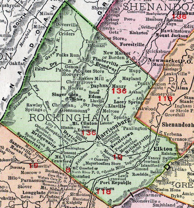
Rockingham County, Virginia 1911 Map

Locations shown include: Almond, Antelope, Arkton, Athlone, Bakers Mill, Beldor, Bridgewater, Broadway, Bruce, Cherrygrove (Cherry Grove), Chestnut Ridge, Chrisman, Cootes Store, Criders, Dale Enterprise, Daphna, Dayton, Dovesville, Edom, Elkton, Fort Hoover, Friedens, Fulks Run, Genoa, Goods Mills, Greenmount (Green Mount), Grottoes, Harrisonburg, Hinton, Holman, Hoover, Hupp, Inglewood, Islandford (Island Ford), Keezletown, Lacey Spring, Latona, Lewis, Lilly, Linville, Linville Depot, Lynwood, Maryland, Massanetta Springs, Mauzy, McGaheysville, Melrose, Meyershoeffers Store, Model, Montevideo, Montezuma, Mount Clinton, Mount Crawford, North River P O, Oakwood, Ottobine, Palos, Paul, Onawan, Paulington, Penn Laird, Pleasant Hill, Pleasant Valley, Port Republic, Rainbow, Rawley Springs, Riverbank, Roadside, Rockingham, Rushville, Rutherford, Scottsford (Scotts Ford), Singer Glen, Sky, Springcreek (Spring Creek), Spring Creek Station, Stemphleytown, Swiftrun (Swift Run), Tenth Legion, Timberville, Tunis, Valeview, Yancey, Zenda.
This Rockingham County map is a portion of a 1911 Virginia map by Rand McNally.
View additional Virginia Maps here: Virginia County Maps
County maps from other states can be viewed here: State County Maps
Use the links at the top right of this page to search or browse thousands of family biographies.