My Genealogy Hound
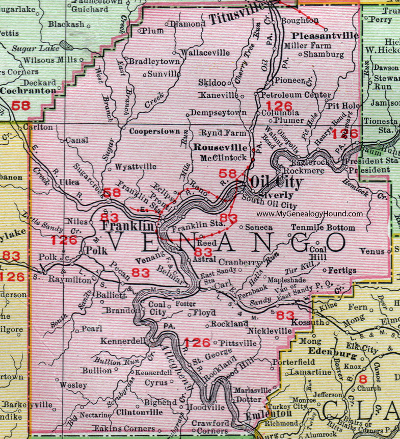
Venango County, Pennsylvania 1911 Map

Locations shown include: Astral * Balliett * Barkleyville *Belmar * Bigbend * Boughton * Bradleytown * Brandon * Bullion * Canal * Carl * Clintonville * Coal City * Coal Hill * Columbia * Cooperstown * Cranberry * Crawford Corners * Cyrus * Dempseytown * Diamond * Dotter * Eaglerock (Eagle Rock) * Eakins Corners * East Sandy P O * East Sandy Station * Eclipse * Emlenton * Fernbank * Fertigs * Floyd * Foster * Franklin * Franklin Station * Henrys Bend * Hoodville * Kaneville * Kennerdell * Mapleshade (Maple Shade) * Mariasville * McClintock * Miller Farm * Nectarine * Nickleville * Niles * Oil City * Oleopolis * Pearl * Pecan * Petroleum Center * Pioneer * Pit Hole * Pittsville * Pleasantville * Plum * Plumer * Polk * Polk Junction * Prentice * President * President Station * Raymilton * Reed * Reno * Rockland * Rockmere * Rouseville * Rynd Farm * Saint George * Seneca * Shamburg * Siverly * Skidoo * South Oil City * Sugarcreek * Sunville * Tenmile Bottom (Ten Mile Bottom) * Utica * Van * Venango * Venus * Wallaceville * Walnut Bend * Wesley * Wood Hill * Wyattville *
This Venango County map is a portion of an 1911 Pennsylvania map by Rand McNally.
View additional Pennsylvania Maps here: Pennsylvania County Maps
County maps from other states can be viewed here: State County Maps
Use the links at the top right of this page to search or browse thousands of family biographies.