My Genealogy Hound
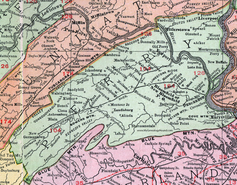
Perry County, Pennsylvania 1911 Map

Locations shown include: Acker * Alinda * Andersonburg * Bailey * Berlee * Bixler * Blain * Bloomfield * Bloomfield Junction * Center (Centre) * Cisna Run * Cove * Coveallen (Cove Allen) * Dellville * Dicks Hill * Donnally Mills * Dromgold * Dums * Duncannon * Elliottsburg * Erly * Eshcol * Fort Robinson * Greenpark * Grier Point * Hench * Hoffman * Iroquois * Juniata Bridge * Juniata Furnace * Ickesburg * Keystone * Kings Mill * Kistler * Landisburg * Lebo * Liverpool * Logania P O * Loshs Run * Loysville * Mahoney * Mannsville * Markelsville * Marshrun (Marsh Run) * Marysville * Millerstown * Montgomerys Ferry * Montour Junction * Mont Park * Mount Patrick * Neilson * Nekoda * New Bloomfield P O * New Buffalo * New Germantown * Newport * Old Ferry * Olmsted * Perdix * Pfouts Valley * Reward * Roddy * Roseburg * Roseglen (Rose Glen) * Royer * Sandyhill (Sandy Hill) * Saville * Shermansdale (Shermans Dale) * Sulphur Spring * Sylvan * Wahneta * Walsingham * Wardville * Water Plug * Wila *
This Perry County map is a portion of an 1911 Pennsylvania map by Rand McNally.
View additional Pennsylvania Maps here: Pennsylvania County Maps
County maps from other states can be viewed here: State County Maps
Use the links at the top right of this page to search or browse thousands of family biographies.