My Genealogy Hound
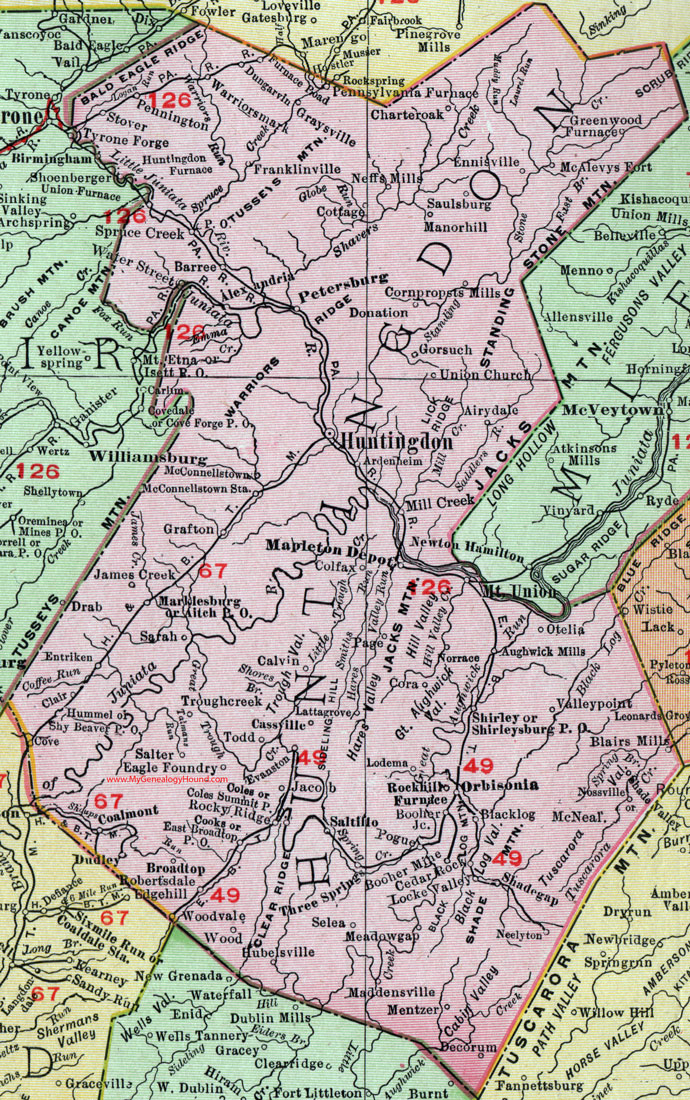
Huntingdon County, Pennsylvania 1911 Map

Locations shown include: Airydale * Aitch P O * Alexandria * Ardenheim * Aughwick Mills * Barree * Blacklog * Blairs Mills * Booher Junction * Booher Mine * Broadtop * Calvin * Cassville * Cedar Rock * Charteroak * Clair * Coalmont * Coles * Coles Summit P O * Colfax * Cooks * Cornpropsts Mills * Cottage * Cove * Decorum * Donation * Dudley * Dungarvin * Eagle Foundry * East Broadtop P O * Ennisville * Entriken * Evanston * Franklinville * Furnace Road * Gorsuch * Grafton * Graysville * Greenwood Furnace * Hubelsville * Hummel * Huntingdon * Huntingdon Furnace * Jacob * James Creek * Lattagrove (Latta Grove) * Locke Valley * Lodema * Maddensville * Manorhill (Manor Hill) * Mapleton Depot * Marklesburg * McAlevys Fort * McConnellstown * McConnellstown Station * McNeal * Meadowgap (Meadow Gap) * Mentzer * Mill Creek * Mount Union * Neelyton * Neffs Mills * Norrace * Nossville * Orbisonia * Otelia * Page * Pennington * Pennsylvania Furnace * Petersburg * Pogue * Robertsdale * Rockhill Furnace * Rocky Ridge * Salter * Saltillo * Sarah * Saulsburg * Selea * Shadegap (Shade Gap) * Shade Valley * Shirley * Shirleysburg P O * Shy Beaver P O * Spruce Creek * Stover * Three Springs * Todd * Troughcreek (Trough Creek) * Union Church * Valleypoint (Valley Point) * Warriorsmark (Warriors Mark) * Water Street * Wood * Woodvale *
This Huntingdon County map is a portion of an 1911 Pennsylvania map by Rand McNally.
View additional Pennsylvania Maps here: Pennsylvania County Maps
County maps from other states can be viewed here: State County Maps
Use the links at the top right of this page to search or browse thousands of family biographies.