My Genealogy Hound
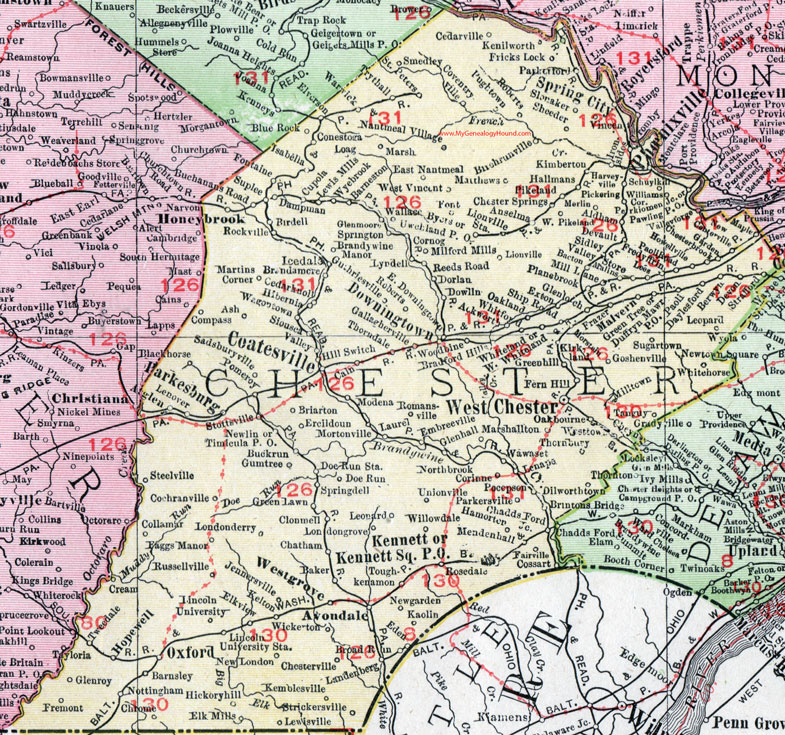
Chester County, Pennsylvania 1911 Map

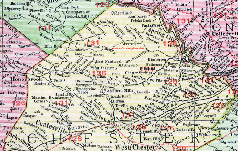
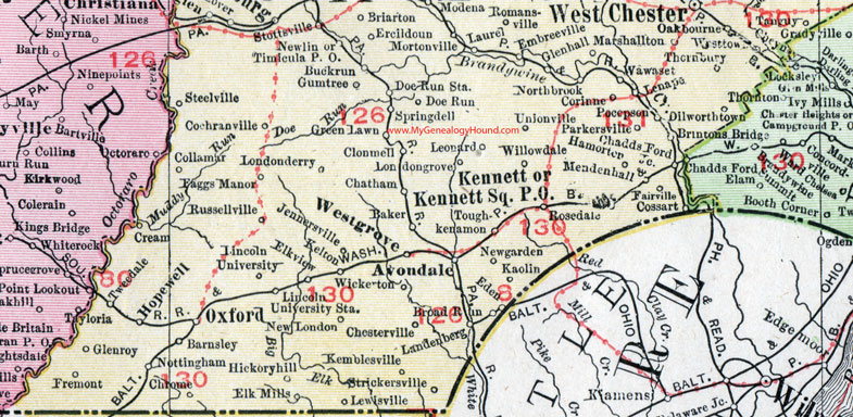
Locations shown include: Ackworth * Aldham * Anselma * Ash * Atglen * Avondale * Bacton * Baker * Barneston * Barnsley * Berwyn * Birchrunville * Birdell * Blackhorse (Black Horse ) * Blue Rock * Bradford Hills * Brandamore * Brandywine Manor * Briarton * Brintons Bridge * Broad Run * Buchanans Road * Buckrun (Buck Run) * Byers * Cain * Cedarknoll (Cedar Knoll) * Cedarville * Chadds Ford Junction * Chatham * Chesterville * Chesterbrook * Chester Springs * Chrome * Clonmell * Coatesville * Cochranville * Collamar * Compass * Conestoga * Corinne * Cornog * Cossart * Coventryville * Cream * Cromby * Cupola * Dampman * Daylesford * Devault * Devon * Dilworthtown * Doe * Doe Run * Doe Run Station * Dorlan * Dowlin * Downingtown * Duffryn Mawr P O * East Downingtown * East Nantmeal * Eden * Elk Mills * Elkview * Elverson * Embreeville * Ercildoun * Exton * Faggs Manor * Fairville * Fern Hill * Font * Fontaine * Frazer * Fremont * Fricks Lock * Gallaghersville * Garden * Glenhall * Glenloch * Glenmoor * Glenroy * Goshenville * Greenhill * Green Lawn * Green Tree * Gumtree * Guthriesville * Hallmans * Hamorton * Harkesburg * Harveyville * Hibernia * Hickoryhill (Hickory Hill) * Hillswitch * Honeybrook * Hopewell * Howellville * Icedale * Iron Sides * Isabella * Jennersville * Kaolin * Kelton * Kemblesville * Kenilworth * Kennett * Kennett Square P O * Kimberton * Kirkland * Landenberg * Laurel * Lenape * Lenover * Leonard * Leopard * Lewis Mills * Lewisville * Lincoln University * Lincoln University Station * Lionville * Lionville Station * Loag * Londonderry * Londongrove * Lyndell * Malins * Malvern * Maple * Marsh * Marshallton * Martins Corner * Matthews * Mendenhall * Merlin * Mill Lane * Milltown * Modena * Morstein * Mortonville * Nantmeal Village * New Centerville * Newgarden (New Garden) * Newlin * New London * Northbrook * Nottingham * Oakbourne * Oakland * Oxford * Paoli * Paoli Head * Parkerford * Parkersville * Parkesburg * Pawling P O * Perkiomen Junction * Phoenixville * Pickering * Pikeland * Planebrook * Pocopson * Pomery * Pughtown * Reeds Road * Roberts * Rockville * Romansville * Rosedale * Russellville * Sadsburyville * Saint Peters * Schuylkill * Sheeder * Ship Road * Sidley * Siousca * Slonaker * Smedley * Spring City * Springdell * Springton * Steelville * Stottsville * Strafford * Strickersville * Sugartown * Suplee * Tanguy * Thornbury * Thorndale * Timicula P O * Toughkenamon * Trythall * Tweedale * Unionville * Uwchland P O * Valley * Valley Store * Vincent * Wagontown * Wallace * Warwick * West Pikeland * Westtown * West Vincent * Wawaset * West Chester * Westgrove (West Grove) * West Whiteland * Whitehorse * Whiteland * Whitford * Wickerton * Williams Corner * Willowdale * Woodbine * Wyebrook *
This Chester County, Pennsylvania map is a portion of an 1911 Pennsylvania map by Rand McNally. See the enlarged map views below.

An enlarged view of northern Chester County, Pennsylvania on an 1911 map by Rand McNally.

An enlarged view of southern Chester County, Pennsylvania on an 1911 map by Rand McNally.
View additional Pennsylvania Maps here: Pennsylvania County Maps
County maps from other states can be viewed here: State County Maps
Use the links at the top right of this page to search or browse thousands of family biographies.