My Genealogy Hound
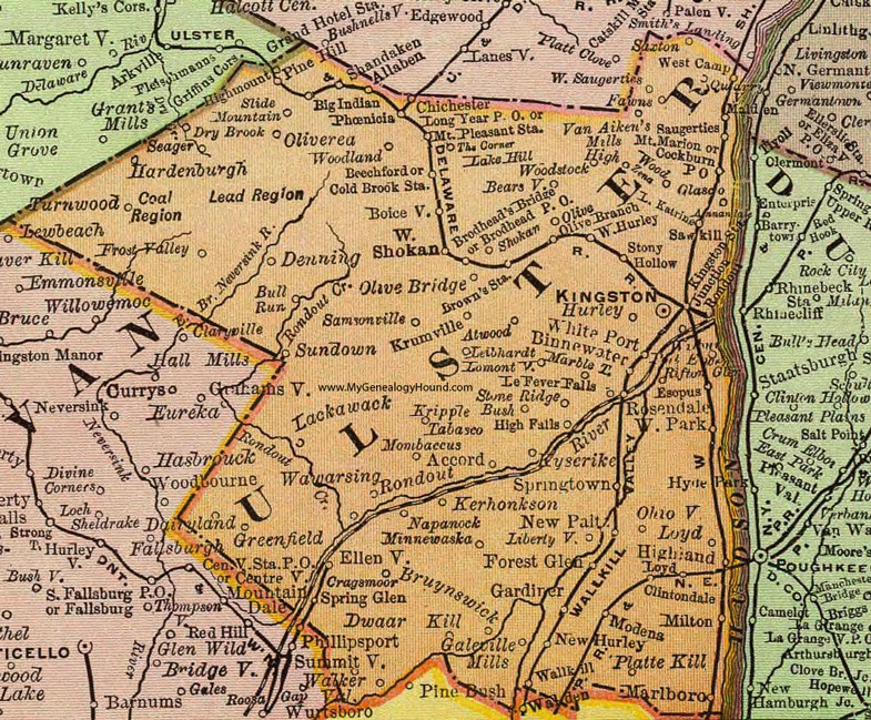
Ulster County, New York 1897 Map

Locations shown include: Accord * Allaben * Atwood * Bearsville * Beechford * Big Indian * Binnewater * Boiceville * Brodhead's Bridge * Brodhead P O * Brown's Station * Bruynswick * Bull Run * Chicester * Clintondale * Cockburn P O * Cold Brook Station * Cragsmoor * Dairyland * Denning * Dry Brook * Dwaar Kill * Ellenville * Esopus * Fawns * Forest Glen * Frost Valley * Galeville Mills * Gardiner * Glasco * Greenfield * Hardenburgh * High Falls * Highland * Highmount * High Wood * Hurley * Kerhonkson * Kingston * Kingston Station Junction * Kripple Bush * Krumville * Kyserike * Lackawack * Lake Hill * Lake Katrina * Le Fever Falls * Leibhardt * Libertyville * Lomontville * Long Year P O * Loyd (Lloyd) * Malden * Marbletown * Marlboro * Milton * Minnewaska * Modens * Mombaccus * Mount Marion * Mount Pleasant Station * Napanock * New Hurley * New Paltz * Ohioville * Olive * Olve Branch * Olive Bridge * Oliverea * Phoenicia * Pine Bush * Pine Hill * Platte Kill * Port Ewen * Quarryville * Rifton Glen * Rosendale * Roundout * Samsonville * Saugerties * Sawkill * Saxton * Seager * Shandaken * Shokan * Slide Mountain * Spring Glen * Springtown * Stone Ridge * Stony Hollow * Summitville * Sundown * Tabasco * The Corner * Turnwood * Van Aiken's Mills * Walker Valley * Wallkill * Wawarsing * West Camp * West Hurley * West Park * West Saugerties * West Shokan * White Port * Woodland * Woodstock * White Port * Zena *
This Ulster County map is a portion of an 1897 New York map by Rand McNally.
View additional New York Maps here: New York County Maps
County maps from other states can be viewed here: State County Maps
Use the links at the top right of this page to search or browse thousands of family biographies.