My Genealogy Hound
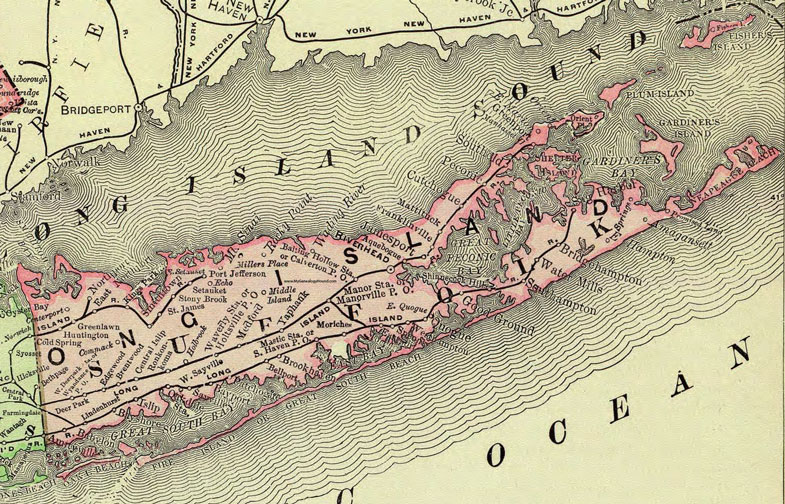
Suffolk County, New York 1897 Map

Locations shown include: Amagansett * Amityville * Aquebogue * Babylon * Baiting Hollow Station * Bayport * Bayshore * Bellport * Brentwood * Bridgehampton * Brookhaven * Calverton P O * Centerport * Central Islip * Commack * Cutchogue * Deer Park * East Hampton * East Marion * East Northport * Eastport * East Quogue * East Setauket * Echo * Edgewood * Franklinville * Greenlawn * Good Ground * Greenport * Holbrook * Holtsville P O * Huntington * Islip * Jamesport * Kings Park * Lindenhurst * Manhasset House * Manor Station * Manorville P O * Mastic Station * Mattituck * Medford * Middle Island * Millers Place * Moriches * Mount Sinai * Northport * Oakdale Station * Orient * Orient Point * Patchogue * Peconic * Port Jefferson * Promised Land * Quogue * Riverhead * Rocky Point * Ronkonkoma * Sag Harbor * Saint James * Sayville * Setauket * Shinnecock Hills * Smithtown * Southampton * South Haven P O * Southold * Speonk * Springs * Stony Brook * Wading River * Water Mills * Waverly Station * West Dee Park Station * Westhampton * West Sayville * Wyandance P O * Yaphank *
This Suffolk County map is a portion of an 1897 New York map by Rand McNally.
View additional New York Maps here: New York County Maps
County maps from other states can be viewed here: State County Maps
Use the links at the top right of this page to search or browse thousands of family biographies.