My Genealogy Hound
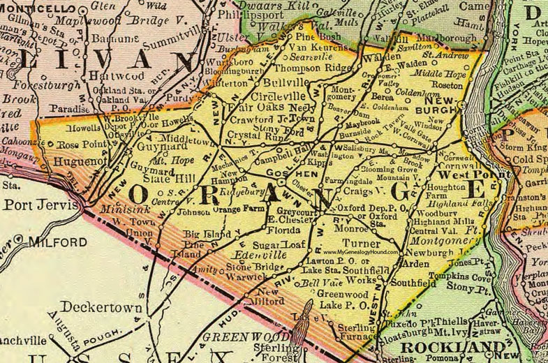
Orange County, New York 1897 Map

Locations shown include: Amity * Arden * Beaver Dam * Bell Vale * Berea * Big Island * Blooming Grove * Bullville * Burnside * Campbell Hall * Central Valley * Centreville * Chester * Circleville * Coldenham * Cornwall P O * Cornwall Station * Craigsville * Crawford Junction * Cronomer Valley * Crystal Run * East Chester * East Coldenham * East Walden * Edenville * Fair Oaks * Farmingdale * Florida * Fort Montgomery * Goshen * Greenwood Lake P O * Greycourt * Guymard * Highland Falls * Highland Mills * Howells * Howells Depot P O * Houghton Farm * Huguenot * Johnson * Kipps * Lake Station * Lakeville * Lawton P O * Maybrook * Meadow Brook * Mechanicstown * Middle Hope * Middletown * Minisink * Mountainville * Monroe * Montgomery * Mount Hope * Neely Town * Newburgh * Newburgh Junction * New Hampton * New Milford * New Windsor * Orange Farm * Otisville * Oxford Depot P O * Oxford Station * Pine Bush * Pine Island * Ridgebury * Rock Tavern * Rose Point * Roseton * Saint Andrew * Salisbury Mills * Savilton * Searsville * Slate Hill * Southfield * Southfield Works * Sterling Furnace * Stone Bridge * Stony Ford * Sugar Loaf * Thompson Ridge * Turner * Tuxedo Park * Unionville * Vails Gate * Van Keurens * Walden * Warwick * Washingtonville * West Brookville * West Cornwall * West Point * Westtown * Woodbury *
This Orange County map is a portion of an 1897 New York map by Rand McNally.
View additional New York Maps here: New York County Maps
County maps from other states can be viewed here: State County Maps
Use the links at the top right of this page to search or browse thousands of family biographies.