My Genealogy Hound
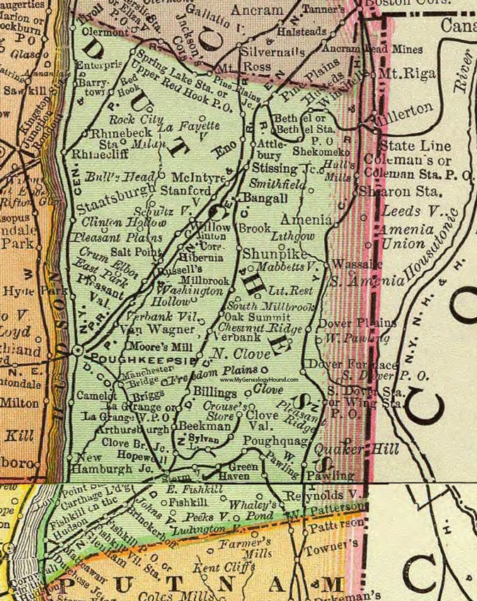
Dutchess County, New York 1897 Map

Locations shown include: Amenia * Amenia Union * Arthursburgh * Attlebury * Bangall * Barrytown * Beekman * Bethel * Bethel Station P O * Billings * Briggs * Brinckerhoff * Bull's Head * Camelot * Carthage Lodge * Chestnut Ridge * Clinton Corners * Clinton Hollow * Clove * Clove Bridge Junciton * Clove Valley * Colemans * Coleman Station P O * Crouse's Store * Crum Elbow * Dover Furnace * Dover Plains * Dutchess Junction * East Fishkill * East Park * Eno * Enterprise * Fishkill * Fishkill P O * Fishkill on the Hudson * Fishkill Village Station * Freedom Plains * Glenham * Green Haven * Hibernia * Hopewell Junction * Hull's Mills * Husteds * Hyde Park * Johnsville * La Fayetteville * La Grange * La Grange P O * Leedsville * Lithgow * Little Rest * Low Point Station * Mabbettsville * Manchester Bridge * Mattcawan * McIntyre * Millbrook * Millerton * Moore's Mill * Mount Riga * New Hamburgh * North Clove * Oak Summit * Pawling * Peeksville * Pine Plains * Pine Plains Junction * Pleasant Plains * Pleasant Ridge * Pleasant Valley * Poughkeepsie * Poughquag * Quaker Hill * Red Hook * Reynoldsville * Rhinebeck Station * Rhinecliff * Rock City * Russells * Salt Point * Schultzville * Sharon Station * Shekomeko * Shunpike * Smithfield * South Amenia * South Dover P O * South Dover Station * South Millbrook * Spring Lake Station * Staatsburgh * Stanfordville * State Line * Stissing Junction * Stormville * Sylvan * Tivoli * Upper Red Hook P O * Van Wagner * Verbank * Verbank Village * Washington Hollow * Wassaic * West Pawling * Whaley's Pond * Willow * Winchells * Wing Station P O *
This Dutchess County map is a portion of an 1897 New York map by Rand McNally.
View additional New York Maps here: New York County Maps
County maps from other states can be viewed here: State County Maps
Use the links at the top right of this page to search or browse thousands of family biographies.