My Genealogy Hound
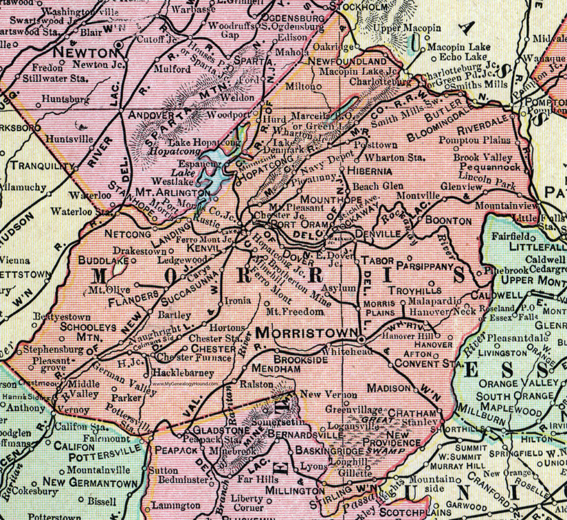
Morris County, New Jersey, 1905 Map

Locations shown include: Afton, Asylum, Bartley, Beach Glen, Boonton, Brookside, Brook Valley, Brotherton Mine, Buddlake (Budd Lake), Butler, Carys, Charlottesburg, Charlottesburg Junction, Chatham, Chester, Chester Furnace, Chester Junction, Chester Station, Colmans Siding, Convent Station, Crestmoor, Denville, Dover, Drakestown, East Dover Junction, Espancug, Ferro Mount, Ferro Mont Junction, Flanders, German Valley, Gillette, Glenview, Green Lake, Green Pond Junction, Greenvillage (Green Village), Hacklebarney, Hacklebarney Junction, Hanover, Hanover Hill, Hanover Neck, Hibernia, Hibernia Junction, Hoptacong, Hoptacong Junction, Hortons, Hurd, Ironia, Kenvil, Lake Denmark, Lake Hoptacong, Lake Junction, Landing, Ledgewood, Lincoln Park, Logansville, Longhill (Long Hill), Madison, Malapardio, Marcella P O, Mendham, Middle Valley, Millington, Milton, Minehill (Mine Hill), Minnisink, Montville, Morris County Junction, Morris Plains, Morristown, Mount Arlington, Mount Freedom, Mount Hope, Mount Olive, Mount Pleasant, Naughright, Navy Depot, Netcong, Newfoundland, New Vernon, Parker, Parsippany, Pequannock, Pickatinny, Pinebrook (Pine Brook), Plains, Pleasantgrove (Pleasant Grove), Pompton, Port Morris, Port Oram, Pottstown, Ralston, Riverdale, Rockaway, Rustic, Schooleys Mountain, Smith Mills Switch, Stanley, Stephensburg, Stirling, Succasunna, Tabor, Troyhills (Troy Hills), Weldon, Wharton Junction, Wharton Station, Whitehead, Woodport.
This Morris County map is a portion of a 1905 New Jersey map by George F. Cram.
View additional New Jersey Maps here: New Jersey County Maps
County maps from other states can be viewed here: State County Maps
Use the links at the top right of this page to search or browse thousands of family biographies.