My Genealogy Hound
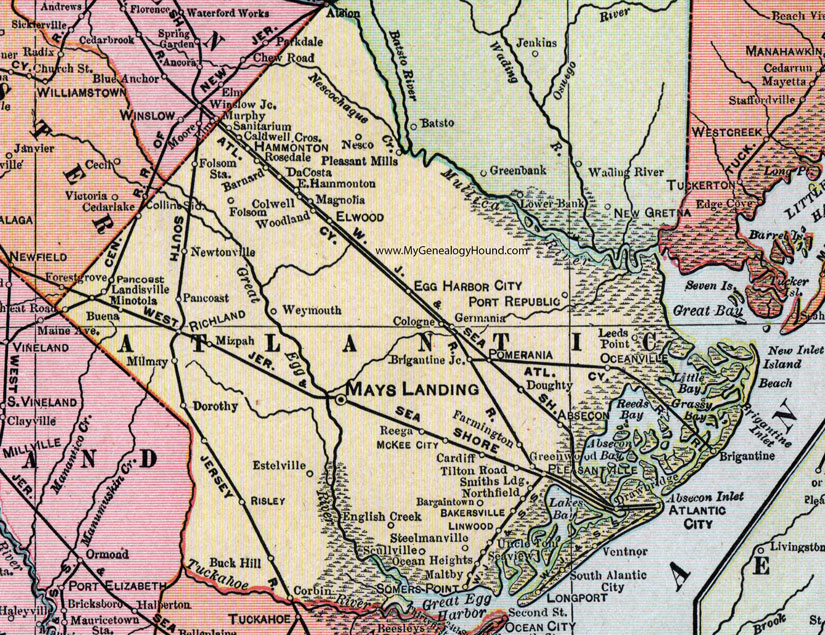
Atlantic County, New Jersey, 1905 Map

Locations shown include: Abescon, Atlantic City, Bakersville, Bargaintown, Barnard, Brigantine, Brigantine Junction, Buck Hill, Buena, Caldwell Crossing, Cardiff, Cedarlake (Cedar Lake), Cologne, Colwell, Corbin, DaCosta, Dorothy, Doughty, Drawbridge, East Hammonton, Egg Harbor City, Elwood, English Creek, Estelville, Farmington, Folsom, Folsom Station, Greenwood, Hammonton, Leeds Point, Linwood, Longport, Magnolia, Maltby, Mays Landing, Landisville, McKee City, Milmay, Minotola, Mizpah, Nesco, Newtonville, Northfield, Ocean Heights, Oceanville, Pancoast, Pleasant Mills, Pleasantville, Pomerania, Port Republic, Reega, Richland, Risley, Rosedale, Sanitarium, Scullville, Seaview, Smiths Landing, Somers Point, South Atlantic City, Steelmanville, Tilton Road, Uncle Tom, Ventnor, Weymouth, Woodland.
This Atlantic County map is a portion of a 1905 New Jersey map by George F. Cram.
View additional New Jersey Maps here: New Jersey County Maps
County maps from other states can be viewed here: State County Maps
Use the links at the top right of this page to search or browse thousands of family biographies.