My Genealogy Hound
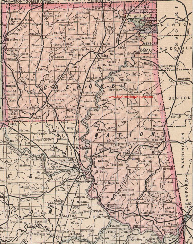
Cherokee Nation Indian Territory 1905 Map

Locations shown include: Adair, Afton, Akins, Albia, Alluwe, Ballard, Baptist, Baron, Bartlesville, Benge, Big Cabin, Blackgum, Blue Jacket, Bluffs, Braggs, Brent, Bunch, Bushyhead, Campbell, Catale, Catoosa, Cayuga, Cedar, Centralia, Chaffee, Chance, Chelsea, Cherokee Junction, Childers, Chloeta, Choteau, Christie, Claremore, Cleora, Collinsville, Coodys Bluff, Cookson, Copan Station, Coretta, Cottonwood, Crittenden, Dawes, Dawson, Delaware, Dewey, Dodge, Dotson, Eagle, Echo, Elliott, Estella, Eucha, Eureka, Fairland, Flint, Foreman, Ft. Gibson, Foyil, Gans, Garfield, Garrison, Gideon, Greenbriar, Grove, Gwenndale, Hanson, Hauto, Hayden, Hillside, Hudson, Kansas, Kelso, Kerk, Ketchum, Kinnison, Klaus, Leach, Lenapal, Locust Grove, Long, Manard, Maple, Marble, Matoaka, McKey, Melvin, Miami, Miles, Mingo, Moodys, Muldrow, Narcissa, Needmore, Nowata, Oak Grove, Oaks, Ochelata, Ogeechee, Oglesby, Okoee, Oologah, Oseuma, Owasso, Owen, Parkhill, Pawpaw, Peggs, Pensacola, Peoria, Polson, Proctor, Pryor Creek, Quapaw, Ramona, Redland, Remy, Rogers, Rose, Ruby, Russell Cr., Sageeyah, Salina, Sallisaw, Seminole Station, Sequoyah, Skiatook, Spavinaw, Stilwell, Suagee, Swimmer, Talala, Tahlequah, Tiawah, Turley, Vera, Verdigris, Vian, Vinita, Wann, Wasson, Watova, Wauhillau, Welch, Weldon, Welling, Westville, White Oak, Whitmire, Wimer, Woodley, Wyandotte, Zena
The upper right (northeast) corner of the map shows the reservations of the Quapaws, Peorias, Ottawas, Modocs, Shawnees, Wyandottes, and Senecas.
This is a portion of a Oklahoma and Indian Nation map by J. N. Matthews, 1903, published 1905.
Reprints of this map are available from Hearthstone Legacy: Cherokee Nation Indian Nation 1905 Map
Share this map to your Facebook page:
View additional Oklahoma County and Indian Nation Maps here: Oklahoma County and Indian Nation Maps
County maps from other states can be viewed here: State County Maps
Use the links at the top right of this page to search or browse thousands of family biographies, historic maps and photographs.