My Genealogy Hound
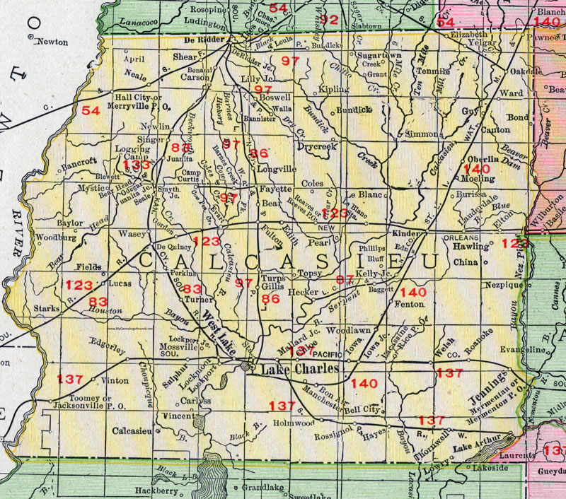
Calcasieu Parish, Louisiana 1911 Map

Locations shown include: April, Baggett, Bancroft, Bannister, Barnes Creek, Baylor, Bear, Bear Head, Bell City, Blewett, Bon Air, Bonami, Bond, Boswell, Bundick, Burissa, Calcasieu, Camp Curtis, Canton, Carlyss, Carson, China, Chloe, Coles, Creek, De Quincy, De Ridder, De Ridder Junction, Drycreek, Edith, Elizabeth, Elton, Edgerley, Edna, Evart, Fayette, Fenton, Fields, Fulton, Gillis, Gordon, Grant, Guy, Hall City, Hawling, Hayes, Hecker, Holmwood, Iowa, Iowa Junction, Jacksonville P O, Jennings, Juanita, Juanita Junction, Kelly Junction, Kinder, Kipling, Lacassine, Lake Aruthur, Lake Charles, Le Blanc, Le Blanc Station, Lily Junction, Lockmoor, Lockport, Lockport Junction, Logging Camp, Longville, Loula, Lowry, Lucas, Mallard Junction, Manchester, Mermentau, Mermenton, Merryville P O, Moeling, Mossville, Mystic, Neale, Newlin, Oakdale, Oberlin, Odegar, Pawnee, Pearl, Perkins, Phillips Bluff, Reaves, Reeves P O, Rice P O, Roanoke, Rossignol, Seale, Shear, Simmons, Singer, Smyth Junction, Starks, Sugartown, Sulphur, Tenmile, Thornwell, Toomey, Topsy, Turner, Turps, Vincent, Vinton, Walla, Ward, Wasey, Welsh, West Lake, Woodburg, Woodlawn, Yelgar.
Note: A large portion of Calcasieu Parish shown on this map was later divided off to create several new parishes:
Allen Parish in 1912
Beauregard Parish in 1913
Jefferson Davis Parish in 1913.
This Calcasieu Parish map is a portion of a 1911 Louisiana map by Rand McNally.
View additional Louisiana Maps here: Louisiana Parish Maps
County maps from other states can be viewed here: State County Maps
Use the links at the top right of this page to search or browse thousands of family biographies.