My Genealogy Hound
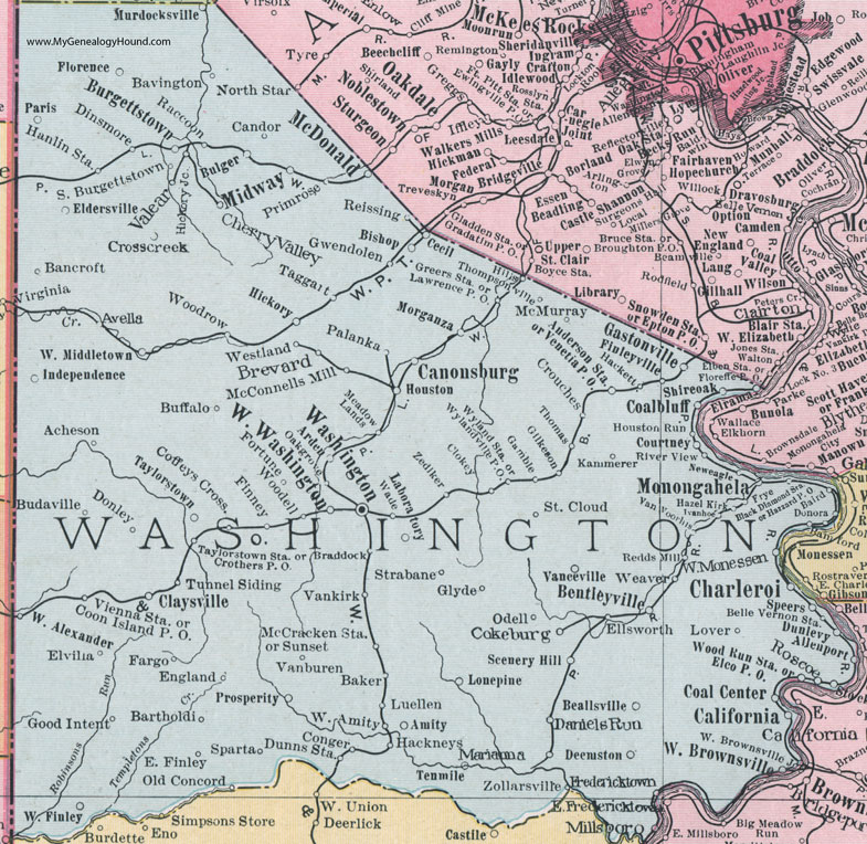
Washington County, Pennsylvania 1911 Map

Locations shown include: Acheson * Allenport * Amity * Anderson Station * Arden * Avella * Baird * Baker * Bamford * Bancroft * Bartholdi * Bavington * Beallsville * Belle Vernon Station * Bentleyville * Bishop * Black Diamond Station * Braddock * Brevard * Budaville * Buffalo * Bulger * Burgettstown * California * Candor * Canonsburg * Cecil * Charleroi * Cherry Valley * Claysville * Clokey * Coalbluff (Coal Bluff) * Coal Center * Coffeys Crossing * Cokeburg * Conger * Coon Island P O * Courtney * Crosscreek (Cross Creek) * Crothers P O * Crouches * Daniels Run * Deemston * Dinsmore * Donley * Donora * Dunlevy * Dunns Station * East Finley * Elben Station * Elco P O * Eldersville * Ellsworth * Elvilla * England * Fargo * Finleyville * Finney * Floreffe P O * Florence * Fortune * Fredericktown * Frye * Gamble * Gastonville * Gilkeson * Glyde * Good Intent * Greers Station * Gwendolen * Hackett * Hackneys * Hanlin Station * Hazel Kirk * Hazzard P O * Hickory * Hickory Junction * Hillis * Houston * Houston Run * Independence * Ivanhoe * Kammerer * Laboratory * Lawrence P O * Lover * Luellen * Marianna * McConnells Mill * McCracken Station * McDonald * McMurray * Meadow Lands * Midway * Millsboro * Monongahela * Morganza * Murdocksville * Neweagle (New Eagle) * North Star * Oakgrove (Oak Grove) * Odell * Old Concord * Palanka * Paris * Primrose * Raccoon * Redds Mill * Reissing * River View * Roscoe * Saint Cloud * Scenery Hill * Shireoak (Shire Oaks) * South Burgettstown * Sparta * Speers * Strabane * Sunset * Taggatt * Taylorstown * Taylorstown Station * Tenmile (Ten Mile) * Thomas * Thompsonville * Tunnel Siding * Valear * Vanburen * Vanceville * Vankirk * Van Voorhis * Venetia P O * Vienna Station * Wade * Washington * Weaver * West Alexander * West Amity * West Brownsville * West Brownsville Junction * West Finley * Westland * West Middleton * West Monessen * West Washington * Woodell * Woodrow * Wood Run Station * Wyland Station * Wylandville P O * Zediker * Zollarsville *
This Washington County map is a portion of an 1911 Pennsylvania map by Rand McNally.
View additional Pennsylvania Maps here: Pennsylvania County Maps
County maps from other states can be viewed here: State County Maps
Use the links at the top right of this page to search or browse thousands of family biographies.