My Genealogy Hound
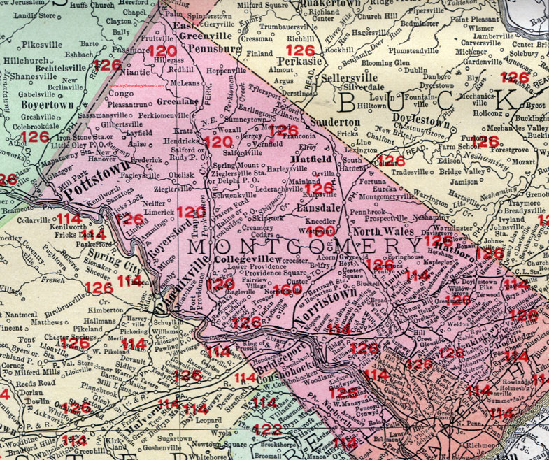
Montgomery County, Pennsylvania 1908 Map

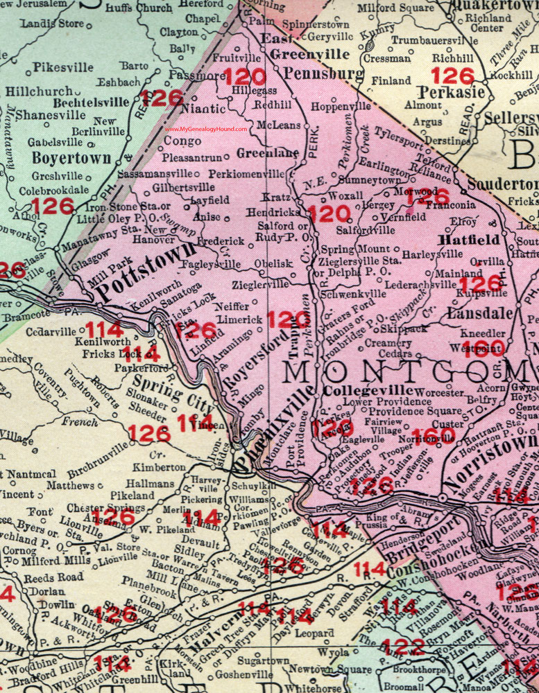
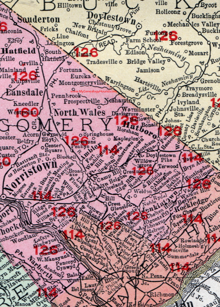
Locations shown include: Abington * Abrams * Acorn * Ambler * Anise * Arcola * Ardmore * Arlingham * Ashbourne * Audubon * Bala * Belfry * Bergey * Bethayres * Betzwood * Bluebell (Blue Bell) * Bonair * Bridgeport * Broadaxe (Broad Axe) * Bryn Athyn * Bryn Mawr * Camp Hill * Cedars * Center Square * Chelten Hills * Cinnaminson * Cold Point * Collegeville * Congo * Conshocken * Corsons * County Line * Creamery * Crestmont * Custer * Cynwyd * Davisgrove (Davis Grove) * Delphi P O * Doylestown Pike * Dresher * Eagleville * Earlington * Earnest (Ernest) * East Greenville * Edge Hill * Elkins Park * Elroy * Enfield * Eureka * Fagleysville * Fairview Village * Flourtown * Fort Hill * Fortuna * Fort Washington * Franconia * Frederick * Fricks Lock Station * Fruitville * Gilbertsville * Gladwyne * Glasgow * Glenside * Graterford * Graterford P O * Green Lane * Gwynedd Valley * Hallowell * Harbers * Harleysville * Hartranft Station * Hatboro * Hatfield * Haverford * Heaton * Henderson * Hendricks * Hill Crest * Hillegas * Hillside * Hooverton P O * Hoppenville * Horsham * Horsham Station * Huntingdon Valley * Ironbridge P O * Ivy Rock * Jarrettown * Jeffersonville * Jenkintown * Kenilworth * King of Prussia * Kneedler * Kratz * Kulpsville * Lafayette * Lafayette Hill * Lansdale * Lavrock * Layfield * Lederach * Limerick * Linfield * Lower Providence * Mainland * Mapleglen (Maple Glen) * Meadowbrook * McLeans * Merion Station * Mill Park * Mingo * Mogees * Montclare (Mont Clare) * Montgomeryville * Morwood * Narcissa * Neiffer * New Hanover * Niantic * Noble * Norristown * Norritonville * North Wales * Oaks * Oaks Station * Obelisk * Ogontz P O * Ogontz School * Orland * Orvilla * Overbrook * Palm * Paper Mills * Pencoyd * Penlynn * Pennbrook * Pennsburg * Perkiomenville * Philmont * Pleasantrun (Pleasant Run) * Plymouth Meeting * Port Indian * Port Kennedy * Port Providence * Pottstown * Prospectville * Protectory * Providence Square * Rahns * Red Hill * Reliance * Ridge Road * Rockledge * Rosemont * Roslyn * Royersford * Rudy P O * Rydal * Salford * Salfordville * Sanatoga * Sassamansville * Schwenkville * Shawm * Skippack * Souderton * South Hatfield * Springhouse (Spring House) * Spring Mill * Spring Mount * Sumneytown * Swedeland * Telford * Terwood * Threetuns (Three Tuns) * Trooper * Tylersport * Tyrol * Valley Falls * Vernfield * Walnut Hills * Weldon * West Coshocken * West Manayunk * Westpoint * William Penn * Williams * Willowgrove (Willow Grove) * Woodland * Worcester * Woxall * Wyncote * Wynnwood (Wynnewood) * Yerkes * Zieglersville * Zieglersville Station *
This Montgomery County map is a portion of an 1908 Pennsylvania map by Rand McNally. See the enlarged map views below.

An enlarged view of western Montgomery County, Pennsylvania on an 1908 map by Rand McNally.

An enlarged view of eastern Montgomery County, Pennsylvania on an 1908 map by Rand McNally.
View additional Pennsylvania Maps here: Pennsylvania County Maps
County maps from other states can be viewed here: State County Maps
Use the links at the top right of this page to search or browse thousands of family biographies.