My Genealogy Hound
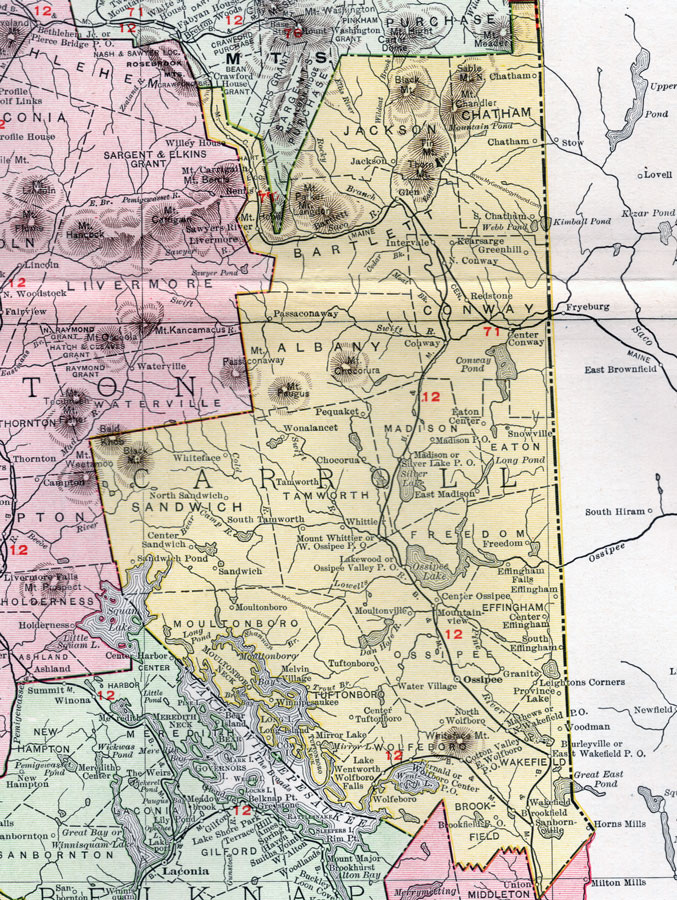
Carroll County, New Hampshire Map, 1912

Locations shown include: Bartlett, Brookfield, Brookfield, Burleyville, Center Conway, Center Effingham, Center Ossipee, Center Sandwich, Center Tuftonboro, Chatham, Chocorua, Conway, Cotton Valley, East Madison, East Wakefield, East Wolfboro, Eaton Center, Effingham, Effingham Falls, Fernald, Freedom, Glen, Granite, Greenhill, Horns Mills, Intervale, Jackson, Kearsarge, Lake Wentworth, Lakewood, Leightons Corners, Long Island, Madison, Mathews, Melvin Village, Mirror Lake, Moultonboro (Moultonborough), Moultonville, Mountainview, Mount Whittier, North Chatham, North Conway, North Sandwich, North Wakefield, North Wolfboro, Ossipee, Ossipee Valley, Passaconaway, Pequaket, Province Lake, Redstone, Sanbornville, Sandwich, Sandwich Pond, Sawyers River, Silver Lake, Snowville, South Chatham, South Effingham, South Tamworth, Tamworth, Tuftonboro, Wakefield, Water Village, West Ossipee, Winnipesaukee, Whiteface, Whittier, Wolfboro (Wolfeboro), Wolfboro Center, Wolfboro Falls, Wonalancet, Woodman.
This Carroll County map is a portion of a 1912 New Hampshire map by Rand McNally.
View additional New Hampshire maps here: New Hampshire County Maps
County maps from other states can be viewed here: State County Maps
Use the links at the top right of this page to search or browse thousands of family biographies.