My Genealogy Hound
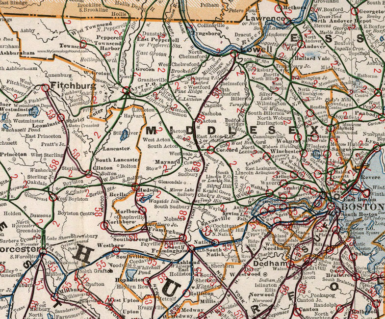
Middlesex County, Massachusetts 1901 Map

Locations shown include: Acton * Arlington * Arlington Heights * Ashby * Ashland * Auburndale * Ayer Junction * Ayer P O * Bedford * Bedford Springs * Belmont * Bemis * Billerica * Bleachery * Brookside * Burlington * Burtts * Cambridge * Cambridgeport * Carlisle * Central Square * Chelmsford * Cherry Brook * Chestnut Hill * Cochituate * Coldspring P O * Collinsville * Concord * Concord Junction * Cummingsville * Dracut * Dunstable * East Acton P O * East Billerica * East Cambridge * East Groton * East Holliston * East Lexington * East Littleton * East Pepperell * East Sudbury * Everett * Forge Village * Framingham * Gleasondale * Glenwood * Graniteville * Groton * Hayden Row * Hollingsworth * Holliston * Hopkinton * Hudson * Kendal Green * Lexington * Lincoln * Lincoln Station * Littleton * Littleton Common * Lowell * Marlboro (Marlborough) * Marlboro Junction (Marlborough Junction) * Malden * Maplewood * Maynard * Meadowview * Medford * Melrose * Metcalf * Middlesex Junction * Middlesex Village * Mirror Lake * Mishawum * Montvale * Montwall? * Munroe's * Nashoba * Natick * Newel * Newton * Newton Highlands * Newton Lower Falls * Newton Upper Falls * Newtonville * Nobscot * North Acton * North Billerica * North Cambridge * North Chelmsford * North Lexington * North Littleton * North Natick * North Pepperell * North Reading * North Sudbury * North Wilmington * North Woburn * North Woburn Junction * Pepperell * Pepperell Station * Pierce's Bridge * Pine Ridge * Reading Centre * Riverside * Saxonville * Sherborn * Shirley * Shirley Center * Silver Hill * Silver Lake * Somerville * South Acton * South Billerica * South Chelmsford * South Lincoln P O * South Natick * South Sherborn * South Sudbury * South Wilmington * Stoneham * Stow * Sudbury * Tewksbury * Tewksbury Junction * Tower Hill * Townsend * Townsend Harbor * Turnpike * Tyngsboro (Tyngsborough) * Waban * Walnut Hill * Waltham * Wamesit * Watertown * Waverly * Wayland * Wayside Inn * West Acton * West Bedford * West Chelmsford * Westford * West Groton * West Newton * Weston * West Somerville * West Townsend * Westvale * Whitneys * Wilmington * Wilmington Junction * Winchester * Winchester Highlands * Woburn * Woburn Highlands * Woodville *
This Middlesex County map is a portion of a 1901 Massachusetts map by Cram.
View additional Massachusetts Maps here: Massachusetts County Maps
County maps from other states can be viewed here: State County Maps
Use the links at the top right of this page to search or browse thousands of family biographies.