My Genealogy Hound
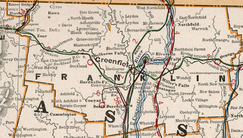
Franklin County, Massachusetts 1901 Map

Locations shown include: Adamsville * Ashfield * Bardwells Fy. * Bernardston * Buckland * Buckland Station * Charlemont * Colerain * Conway * Conway Junction * Conway Station * Cooleyville * Cyrus * Davis * Deerfield * Dell * East Charlemont P O * East Deerfield Station * East Northfield * East Shelburne * East Whately * Elm Grove * Erving * Farley * Gill * Greenfield * Griswoldville * Hawley * Heath * Heywoods * Lake Pleasant * Leverett * Leyden * Locks Village * Logans * Lyonsville * Miller's Falls * Millington * Monroe * Monroe Bridge * Montague * Montague City * Montague Station * Mount Hermon * New Salem * Northfield * Northfield Farms * North Heath * North Leverett * North New Salem * North Orange * Orange * Riverside * Rowe * Shattuckville * Shelburne * Shelburne Falls * Shutesbury * South Ashfield * South Deerfield * Spruce Corner * Sunderland * Tully * Turner's Falls * Turner's Falls Junction * Warwick * Wendell * Wendell Depot * West Deerfield * West Hawley * West Leyden * West Northfield * Whately * Zoar *
This Franklin County map is a portion of a 1901 Massachusetts map by Cram.
View additional Massachusetts Maps here: Massachusetts County Maps
County maps from other states can be viewed here: State County Maps
Use the links at the top right of this page to search or browse thousands of family biographies.