My Genealogy Hound
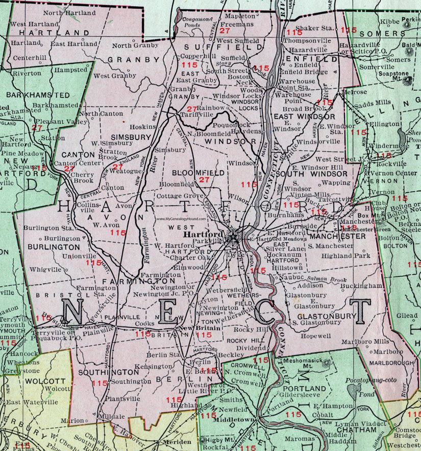
Hartford County, Connecticut, 1911 Map

Locations shown include: Addison, Avon, Beckley, Berlin, Berlin Station, Bloomfield, Bristol, Broad Brook, Buckingham, Buckland, Burlington, Burlington Station, Burnhams, Burnside, Canton, Canton Center, Centerhill, Charter Oak, Cherry Brook, Clayton, Collinsville, Cooks, Copperhill, Cottage Grove, Dividend, Dyke, East Berlin, East Glastonbury, East Granby, East Hartford, East Hartford Meadows, East Hartland, East Windsor, East Windsor Hill, East Windsor Station, Elmwood, Enfield, Enfield Bridge, Farmington, Farmington Station, Freemans, Glastonbury, Granby, Hartford, Hartland, Haydens, Hazardville, Highland Park, Hillstown, Hockanum, Hopewell, Hoskins, Kensington, Manchester, Manchester Green, Mapleton, Milldale, Marion, Marlboro, Marlboro Mills, Melrose, Naubuc, New Britian, Newington, Newington Junction P O, North Bloomfield, North Canton, North Granby, North Hartland, Parkville, Pequabuck P O, Plainville, Plantsville, Poquonock, Rainbow, Rocky Hill, Scitico P O, Shaker Station, Silver Lane, Simsbury, Southington, South Glastonbury, South Manchester, South Street, South Wethersfield, South Windsor, Stratton Brook, Suffield, Tariffville, Terryville, Thompsonville, Unionville, Vinton Mills, Wapping, Warehouse Point, Warehouse Point Station, Weatogue, Wethersfield, West Avon, West Granby, West Hartford, West Hartland, West Simsbury, West Suffield, Whigville, Wilson, Windsor, Windsor Locks, Windsorville, Woods.
This Hartford County map is a portion of a 1911 Connecticut map by Rand McNally.
View additional Connecticut Maps here: Connecticut County Maps
County maps from other states can be viewed here: State County Maps
Use the links at the top right of this page to search or browse thousands of family biographies.