My Genealogy Hound
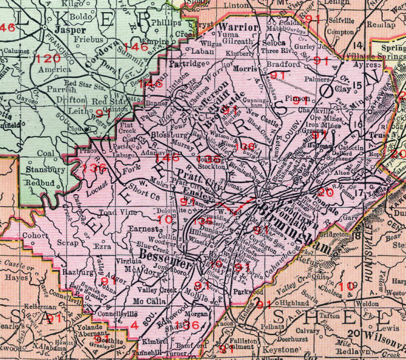
Jefferson County, Alabama, 1911 Map

Locations shown include: Adamsville, Adger, Alabama Rolling Mill, Alton, Argo, Avondale, Ayres, Bamford, Banner, Belle Sumter P.O., Bessemer, Birmingham, Black Creek, Blossburg, Blue Creek Junction, Boyles, Bradford, Brick Yard Junction, Brookside, Bryan, Cardiff, Catoctin, Chalkville, Chetopa, Clay, Coalburg, Coal Creek, Coaldale, Cohort, Collins, Connellsville, Connellsville Junction, Coyington, Cunningham, Dago, DeBard, Dolomite, Duncan, Earnest, East Birmingham, East Lake, Edgewood, El Vista, Ensley, Ezra, Flat Creek, Gary, Gate City, Gilreath, Greene, Green Springs, Gurley Junction, Hedora (Hedona?), Henryellen, Hiawatha, Hillman, Huffman, Huron, Irondale, Iron Mines, Ishkooda, Jefferson, Johns, Jonesboro, Ketona, Kewanee, Kimberly, Kimbrel, Laban, Labugo, Leeds, Lewisburg, Littleton, Lowick, Mabel, Magella, McAdory, McCalla, McCombs, Merkel, Mineral Springs, Mines, Mobile Junction, Morgan, Morris, Mulga, Murray, New Castle, North Birmingham, Ore Mines, Oxmoor, Palmers, Palos, Parkwood, Partridge, Pinson, Porter, Powderly, Praco, Pratt City, Pratt City Station, Razburg, Readers, Redding, Refuge, Red Gap Junction, Republic, Roper, Ruffner, Sayre, Scrap, Seloca, Short Creek, Sloss, Sloss Mine, Spaulding Junction, Steinman, Stephens, Stockton, Sumter, Toad Vine, Thomas, Three Rivers, Trussville, Turner, Turpin, Valley Creek, Village Springs, Virginia, Vulcan, Wares, Warrior, Watson, Weems, West End, Wheeling, Wilgus, Winetka, Woodlawn, Woodward, Woodward Junction, Wylam, Yuma.
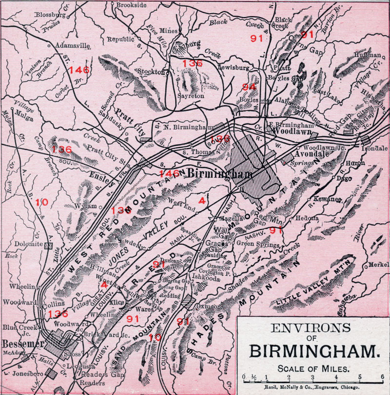
An enlarged view of the Birmingham area is below.

Locations shown include: Adamsville, Alabama Rolling Mill, Alice, Avondale, Bessemer, Black Creek, Blue Creek Junction, Blossburg, Boyles, Boyles Gap, Brick Yard Junction, Brookside, Coalburg, Covington P.O., Dago, Dolomite, Duncan, East Birmingham, East Lake, Ensley, Fossil, Gate City, Graces, Green Springs, Hedona, Hiawatha, Hillman, Huffman, Huron, Irondale, Ishkooda, Jonesboro, Kewanee, Leogusta, Lewisburg, Magella, McAdory, Merkel, Mines, Mulga, North Birmingham, Oxmoor, Platt, Powderly, Pratt City, Pratt City Station, Readers, Redding, Red Gap Junction, Republic, Sandusky, Sayreton, Skyhy, Sloss, Spaulding, Spaulding Junction, Spring Gap, Spring Gap Junction, Steinman, Stockton, Thomas, Wades Gap, Wares, West End, Wheeling, Winetka, Woodlawn, Woodlawn Junction, Woodward, Woodard Junction, Wylam.
These Jefferson County maps are a portion of a 1911 Alabama map by Rand McNally.
View additional Alabama County Maps here: Alabama County Maps
County maps from other states can be viewed here: State County Maps
Use the links at the top right of this page to search or browse thousands of family biographies.